
There’s no substitute for real data when we are trying to anticipate conditions out on Lake Michigan, or when we are seeking to square what we’ve experienced with actual wave heights and wind speeds. Without data, the stories paddlers tell about the waves they battled can be no more accurate than fish tales (“You should have seen the one that got away!”). More importantly, without data, we don’t learn as much from our experiences because we can’t connect the conditions we were in with future forecasts.
We’ve long relied on the National Oceanic and Atmospheric Association’s buoy 45007, located 43 nautical miles ESE of Milwaukee, as one of our prime data points for wave heights and wind speeds, but that’s a long way from the Chicago shore. A local anemometer, located on one of Chicago’s offshore water intake cribs, provides us with accurate wind speeds. We had to extrapolate from Milwaukee wave data and Chicago wind data to figure out what to expect here. (Data from the Michigan City buoy also can be useful, depending on the direction of the wind and waves.)
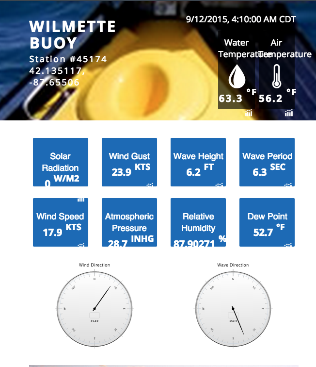
So you can imagine our excitement when we learned of a new buoy far closer to home: buoy 45174, located about five miles east of Wilmette. It was installed last month, and it has a beautiful website with lovely graphs. One recent evening, when the marine forecast (which is updated only four times every 24 hours) called for waves of 4 to 7 feet, we were able to confirm that the wave height at the Wilmette buoy was 5.9 feet. That meant we really knew what to expect before going out on the lake, and we could authoritatively connect the experience we had with actual wave heights and periods.
During a time of diminished funding for public services, we were especially excited about the existence of a new buoy. So we contacted Jay Beugly, aquatic ecology specialist at Perdue University in West Lafayette, Indiana, who works with the Illinois-Indiana Sea Grant College Program on research, outreach and education.
“We already had a buoy in Michigan City that a lot of boaters use, as well as the DNR [Department of Natural Resources] and NOAA [National Oceanic and Atmospheric Association] to update weather forecasts, and we knew that the Chicago region was kind of lacking offshore information,” he explains. Last year, when he attended the Chicago Boat, RV & Strictly Sail Show, he connected with others who shared his interest in increasing offshore data and were willing to help make it happen.
Kayakers expressed a preference for buoys close to shore, weather forecasters a little further out, and fishermen further still. “It was a compromise between them,” he says of the buoy’s placement. The challenge of placing the buoy, with its 2,200-pound cement anchor, was nicely chronicled by the Chicago Sun-Times. Then there was a leak in the buoy that corrupted some of the data, followed by some programming challenges getting the real-time data properly reflected in the long-term charts. “We’re still working on getting those to read right,” Beugly says. (Right now, the charts don’t properly reflect the actual data.) But despite those glitches, the buoy is now providing accurate information about wind speed and direction, and wave height, direction and period.
Beugly hopes Chicago will see another new buoy some time in the future. “Long-term, we would love to see one further south along the Chicago shoreline,” he says. “But that’s a ways off.” Meanwhile, he says, paddlers and others can request additional data from the Wilmette buoy, such as water temperature at different depths, dissolved oxygen and turbidity, by contacting Jay at jbeugly@purdue.edu.
So now we have another destination for an off-shore paddle this year: We need to visit buoy 45174 before Jay and others return in late October and put it away for the winter.

Jay Beugly. Photo courtesy of Anjanette Riley


Congratulations on the wonderful new addition to your paddling family.